 Friday the 13th found us driving the Denali Highway for a weekend of car camping. Completed in 1957 to provide motorists with access to Denali National Park, the Denali Highway found itself virtually abandoned in 1972 when the paved George Parks Highway opened, linking Anchorage and Fairbanks directly with the park. Since then the Denali Highway has served mainly as a passage into the back country for hunters and fishermen and as a byway for those seeking a peek at the way all of Alaska used to look, with wilderness in every direction. And now that the once-rugged Alaska Highway, linking Alaska with the Lower 48, has been paved, the Denali Highway is one of the last accessible roads in Alaska that can provide that rustic, nostalgic glimpse.
Our trip began with a view of an afternoon rainbow just before we reached Brushkana Creek at mile 30. We had camped here before so we decided to press on down the road for a more isolated spot. Wound up driving all the way to Clearwater Creek. A nice spot to camp next to the water. The noise of the creek was just the tonic for one of the better nights sleep I've had in a long while. Even managed to snag some sourdough pancakes with birch syrup for breakfast
Continuing on the next day we were treated to the sight of a tundra swan family: Mom Dad and four Cygnets swimming across a small duck filled lake. After taking a few pics we headed east again taking in the views of Maclaren Glacier, an area we hiked last summer. Beautiful scenery and at 4200 feet Maclaren Summit is the second highest highway summit in Alaska.
Pushing still eastward we hit new territory that we hadn't explored last summer including Landmark Gap, a glacially-scoured cut in the mountains that formed during an Ice Age more than 10,000 years ago. The Gap was a caribou migration route and a favorite Indian hunting area in centuries past. The Nelchina caribou herd still migrates through this area. The mountain peaks visible through the Gap are McGinnis Peak (11,400') and Mt. Moffit (13,020').
 Next up was the Tangle Lakes area. The lakes are connected by the Tangle River and form the headwaters of the Delta River. Unfortunately our luck left us just east of the lakes as we started to notice adisturbing noise coming from the right front wheel. Didn't know what it was but it didn't sound good. We limped the next 70 miles into Delta Junction where our problem was diagnosed as blown wheel bearings. We were very thankful that we made it to somewhere that repair was possible.
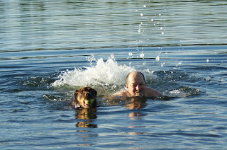
So repairs complete, we inspect the town of Delta Junction. This is the official end of the Alaska Highway although many never make it this far as there is an alternative route to Anchorage via the Tok cutoff. Nice visitors center with free coffee and some interesting statutes of mosquitos. From Delta Junction we drive northwest to North Pole Alaska for some replenishing of supplies and then backtrack just a bit to Chena Lake State Recreation Area. Temps are hitting mid 80s so we make like Champ and take a dip in the water. First time for me to go swimming since I've been here. Very refreshing!


1 comment:
Sounds like a grat weekend!
Post a Comment